



**Google Earth Gets AI-Powered Image Generation with Nano Banana: Fun, But Not Perfect**
*By David Gewirtz/ZDNET*
Google Earth has taken a significant step into the future with the integration of AI-based image generation. The search giant has embedded its cutting-edge “Nano Banana” model directly into the platform, transforming how users can visualize and interact with geographic locations. This new feature allows users to generate custom AI images based on specific prompts, offering a creative layer on top of the existing mapping and exploration tools. But is it a game-changer for serious geographic work, or is it just a fun new toy? Let’s dive in.
### **Key Takeaways**
* Google Earth now features AI image generation powered by the Nano Banana model.
* The tool is primarily entertaining and great for creative visualization rather than serious professional applications.
* The AI treats locations as visual prompts rather than understanding the geographic or cultural context, leading to sometimes bizarre results.
### **The New “Create Image” Feature**
Accessible through the new “Create Image” button in the Google Earth toolbar, the Nano Banana integration allows users to generate visual representations of any location they are viewing. The process is straightforward: navigate to a point on the globe, select the location, and type in a descriptive prompt.
**Example: Visualizing a Future City**
For example, you could take a satellite view of an empty 200-mile stretch of land in Palm Bay, Florida, known as “The Compound,” and prompt the AI to “make this into a vibrant community with a shopping district, a neighborhood, and historical-style homes appropriate for central Florida.” The result is a fascinating, if not entirely accurate, visualization of what that space could look like.
### **Strengths and Limitations: It’s for Fun, Not Analysis**
While the technology behind Nano Banana is impressive, its integration into Google Earth highlights its current limitations. The AI doesn’t understand a location’s history, culture, or architectural principles. It treats the screen like a screenshot and fills in the blanks based on patterns it has learned from training data.
* **Architectural Rendering Attempts:** When trying to add a “wrap-around front porch” to a house in New Jersey using Street View, the AI frequently fails. It often picks the wrong house entirely and can generate illogical extensions that spill into neighboring properties. For architectural work, using a dedicated image generator like Gemini directly with a screenshot from Street View proves to be more effective.
* **Historical Reimagining:** The feature shines when used for creative historical “what-if” scenarios. Asking Google Earth to show Independence Hall in July 1776 produces a plausible, if somewhat generic, colonial-era rendering. You can then ask to see the same location in 1876 or 1976, and the AI will generate period-appropriate (though not historically accurate) versions of the buildings.
### **A Surreal Experience: When AI Logic Breaks Down**
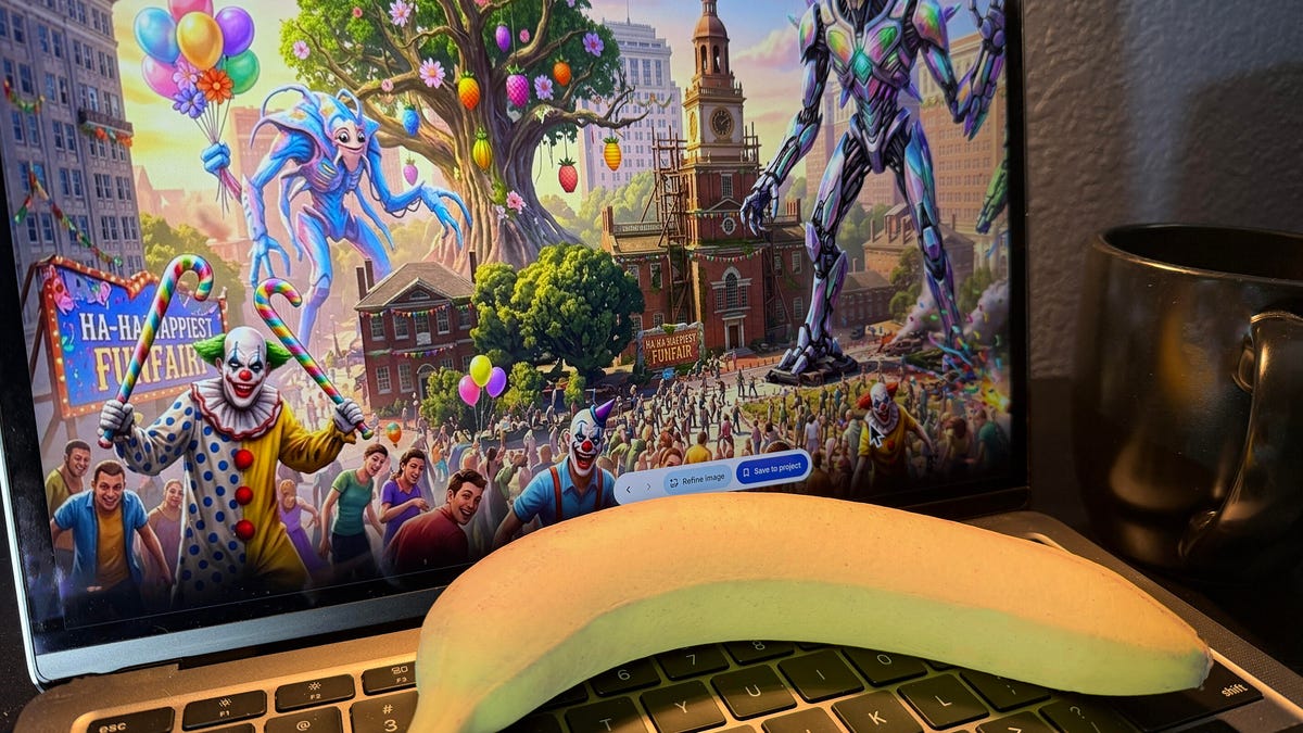
The most entertaining part of the feature is when the AI’s logic fails in spectacular ways. Prompting a futuristic version of Independence Hall resulted in an “Ethical Genomic Archive” with bizarre text and strange architectural choices. Asking for a “post-apocalyptic dystopian future” initially turned the historic buildings into ruins, but a follow-up prompt to “make them cheerful” resulted in a scene that looked like a bizarre holiday-themed zombie apocalypse.
### **Conclusion: A Powerful Tool with a Long Way to Go**
Google Earth’s integration of Nano Banana is a significant step forward for AI-image generation, making the technology accessible to millions of users. However, it’s crucial to understand its purpose. It’s not a professional tool for cartography, architecture, or geographic analysis. It’s a tool for exploration, creativity, and fun.
The AI acts more as a collaborative partner than an accurate source of information. It provides a starting point for imagination, allowing users to visualize “what if” scenarios in a way that is engaging and often hilarious. While it lacks the depth and reliability needed for serious work, its potential for sparking creativity and making geographic exploration more interactive is undeniable. As Google continues to develop this feature, we can expect it to become a more valuable and integrated part of the Google Earth experience.
***
## FAQ
**Q: What is Nano Banana?**
A: Nano Banana is Google’s advanced AI image generation model. It can create high-quality images from simple text prompts and has been integrated into various Google services, including Google Earth.
**Q: How do I access the AI image generation feature in Google Earth?**
A: Look for a “Create Image” button in the Google Earth toolbar. Click it, select a location on the map, and type in your prompt.
**Q: Can I use this feature for serious work like architectural planning or geographic research?**
A: No. The tool is not reliable for professional or analytical work. It treats locations as visual subjects rather than understanding their context, which can lead to inaccurate and nonsensical results. It is best used for creative brainstorming and entertainment.
**Q: Why does the AI sometimes generate incorrect buildings or text?**
A: The AI is not “seeing” the location in the way a human does. It’s generating an image based on a prompt and a pattern-matching process. It doesn’t have a deep understanding of geography, history, or the physical structures it is asked to create, which is why it can make significant errors in details like building placement or text.
**Q: Will Google improve this feature in the future?**
A: It’s highly likely. Given that Google has access to massive amounts of data and is continuously improving its AI models, future versions of this feature will likely be more accurate, better integrated with real-world data, and more useful for practical applications.
***
## Conclusion
Google Earth’s new AI image generation feature, powered by Nano Banana, is a testament to how far AI technology has come. It successfully blends the utility of a mapping tool with the creative potential of generative AI. While it stumbles when tasked with accuracy, it excels at sparking imagination and providing a fun, interactive way to reimagine our world. It’s not a tool for the serious cartographer, but it is a fantastic toy for the curious mind. As these technologies evolve, the line between exploration and creation will only continue to blur, and the future of how we interact with digital maps looks more imaginative than ever.
